Sense of Place (SnsPlace)
Sense of Place combines a comprehensive statistical database
with a set of simple visualization techinques to allow students
to gain an understanding of the characteristics of U.S. counties.
Students can examine data for any one of the statistical variables
in the database. In addition, students can create metrics consisting
of target values for several variables, and rate counties
by how closely their data match the targets.
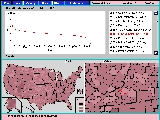
Symbolic mapping is used to illustrate spatial characteristics of
a state or county, such as its size, shape, and location, as well
as regional patterns among different counties.
Graphing is used to illustrate basic concepts of data distributions
and to depict the distributions of specific variables.
A spreadsheet is used to view the multivariate data sets created by
user metrics.
Click on this image to see a full size version:
Get Sense of Place Here
For information about GeoSim, contact us at:
shaffer AT cs DOT vt DOT edu.
Last updated: 07/07/2006.
